Date: June 24, 2023
Location: Fernie, British Columbia, Canada
Total Trip Distance: 8.53 mi / 13.73 km Total Elevation Gain: 4,188 ft / 1,277 m
Trip Duration: 6 hours
Team: With Alex Catalfamo
Field Notes: This is one of my favorite off-trail hikes / scrambles in the Fernie area. Accessible from town and a very efficient route to the summit. The only difficulty is the summit ridge, which is straightforward and easy off-trail hiking / scrambling. A helmet is not required. There is no water on route.
Rating: Class 2

Approach
Alex and I arrived in town about a week before we did this trip and we were frothing to get up high. I had spent the last six months in Hawaii working with the most incredible healer and friend, Jack Fonderwhite. He was helping to get my body back to climbing mountains after a seven year recovery process from a big injury, but that's a story for another day. Point is - I hadn't been in big mountains in a long time. Probably somewhere close to three years.
We did a warm up on Mount Fernie Ridge on Wednesday and decided on Hosmer for the weekend. Hartley Lake Road isn't great but it's manageable with a low clearance, 2wd car. We went slow and found our way around the potholes. About a twenty minute drive from town and we were the only car at the parking lot. With the sun heating up early, we wasted no time and started up.

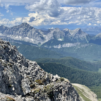
The trail is efficient. We went straight up with views of Proctor and Three Sisters gradually becoming better and better. The higher we climbed, the higher my spirit rose. It felt great to be back in the mountains. At the col just below Ghostrider Mountain the views really open up from a ledge. It was cool to see the accessibility of mountain trips in Fernie. Right from town you have a lot of great day trips and we felt as if we made the right choice for this to be our base camp for summer.

Mount Hosmer
From the col below Ghostrider one needs to pay attention to route-finding to make the correct left hand turn for Hosmer. I use the Gaia app for navigation in the mountains and it has never let me down (I also have a Garmin inReach but only use this for emergency). The route map photo at the top of the page is the exact route we took, so look for a very faint herd path to your left by a grassy area. As you follow this rough path, it diverts into the woods. The trail becomes marked by orange flagging tape.

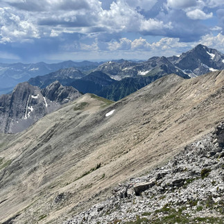
We followed this trail and the flagging tape until it became harder to follow as we entered the basin. From here, we bushwhacked straight up the basin through the woods and travel was simple. Eventually, we made a left to begin climbing up to meet the summit ridge of Mount Hosmer. The photo below is the ascent route of Mount Hosmer taken from Ghostrider Mountain.

We took the left turn slightly early and it became pretty steep with loose rocks. Not a big deal, but I'd recommend using the route map photo above which shows the easiest travel to meet the summit ridge (this is what we took on the descent). Travel in the basin until you have a clear view of the climb above and simply pick the easiest route of ascent.

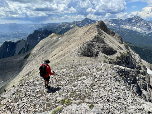
Once on the summit ridge, navigation is extremely straightforward. We followed the summit ridge, becoming airy at times, up and over a false summit. This is where it became really fun. The ridge narrows and provides incredible 360 degree views. The ridge is never more than a class 2 scramble - which is off trail, but climbing with your hands. There are steep drop offs on each side which gives it kind of a "lofty" feeling.


When we reached the summit, Alex congratulated with me with two simple but powerful words - "welcome back." I thought I'd become very sentimental and emotional to finally stand on a relatively big mountain again, but rather I didn't feel much. It was just good to be back. Finish lines are an illusion and when one reaches any summit, the view is of other summits. It never ends.


We signed the summit register, snapped photos, took off our shoes and chilled. It was a perfect day to be in the mountains. When we were ready we made the descent back to the car, taking the same route. Of course, the day ended with a cold soak in the Elk River and plenty of delicious Indian food.


Happy days...
Comments