Mount Daly and Mount Niles
- Mike Morelli

- Jul 24, 2023
- 5 min read
Updated: Dec 10, 2024
Date: July 21 - 23, 2023
Location: Yoho National Park, British Columbia, Canada
Total Trip Distance: 23.89 mi / 38.44 km Total Elevation Gain: 8,063 ft / 2457 m
Trip Duration: 3 Days
Team: With Alex Catalfamo
Field Notes: This trip can be completed in 2 days, but we opted for 3 to have a slightly less aggressive pace and to spend more time in the mountains. While none of the scrambling is overly difficult, the terrain on Daly is very loose and steep so I would strongly recommend a helmet. There is plenty of water where we camped. There was also water flowing just past the Niles glacier before the ascent up Daly.
Rating: Class 3

Niles Meadows via Sherbrooke Lake
After tossing around a variety of different ideas for a 3-day weekend, Alex and I finally settled on a trip to Yoho National Park. This was our first time in this park and it did not disappoint. With a perfect forecast, we made the three and a half hour drive from Fernie. We arrived at the trailhead, had a quick PBJ, strapped on our packs and began the 6-7 mile approach to Niles Meadows.
The approach is easy with a defined trail the entire way. You steadily climb a few hundred feet on the way to Sherbrooke Lake. From there, the trail continues on the hikers right of the lake. I couldn't resist a quick swim in the beautiful water. From there the trail meanders through meadows, steadily climbing through forest. No need to carry much water as you are never far from it during the entire approach.

At last we reached Niles Meadows where we were greeted with a beautiful view of Mount Niles. It was wet in the meadows so we decided to expend the extra energy and climb another 500 feet. I'm glad we did. The views were amazing, it made the climbs shorter, there were (slightly) less bugs, and we had water in abundance.

We set up camp, cooked an entire box of pasta, and hunkered down for the night. As the sun set, we were treated to an incredible thunderstorm that passed directly overhead.


Mount Daly
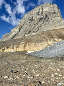
There are some days where the numbers don't tell the full story. While only 7 miles and 3,200 feet from our camp, Daly was a pig. We crawled out of our sleeping bags around 5:30 after sleeping for maybe an hour or two. The sunrise was beautiful and I soaked it in while drinking a hot coffee. By seven we were ascending the ridge above camp. From there, we crossed the basin between Niles and Daly. The terrain here was okay and we made decent time. We decided to avoid the glacier as we didn't have spikes. I don't think there would have been any difference in time savings either.

After crossing the basin, we climbed up to reach a col between a small cone summit and the slopes of Mount Daly. What took place for the next two hours was endless scree grinding and loose rock hopping. It was some of the worst terrain I've ever been on. Maybe I just haven't spent enough time in the Canadian Rockies. The terrain was quite loose and very steep - I'm glad we wore helmets.


In reading route descriptions prior to the trip, there was mention of a "class 4 scrambling crux" when one reaches an obvious rock band after climbing above the small summit cone. The rock band is obvious, but we decided to sidle to the climbers right and found very easy slopes we could simply walk up, although still very steep and loose.
Once passed the "crux", we climbed another 800 feet where we reached the false summit. Some maps may mark this as the official summit, however, the summit register is on the other peak a mere fifteen minutes away. To me, it is well worth it to climb the ridge between the two summits. It's airy and has an exposed move or two that adds some flair to the trip. The climbing is easy. In my opinion, this was the "crux," although it's nothing more than exposed scrambling with perfect rock.

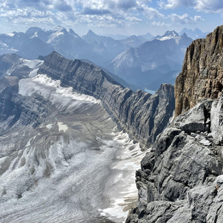
The views from the true summit are spectacular with mountains in all directions. It is definitely a remote peak - there were on average five to six successful summit parties (that signed the register) per year. 2021 only saw four. In 2023, we were the third. We felt extremely lucky to stand on this massive peak.


After snapping some photos and signing the register, we made the climb back down to camp. I found the descent to be quite frustrating. You couldn't trust a single step. It felt like every rock would shift or move under my feet which resulted in a slip or two. Secondly, the sole of my right boot was getting torn off and Alex's shoes were getting holes in them. The Canadian Rockies were eating our footwear alive this summer.

Care had to be taken on the descent as rocks would release and create hazard for the climber below. We decided to fan out and take our time. Incredibly, we saw a party of two climbing Daly as we descended. They were quite keen, deciding to do it in a day.
Our last difficulty was descending the scree back down to the col between the cone shaped summit and Daly. We did of a combination of down climbing and sliding, roughing our hands in the process. Eventually we made it back down to the basin and and hustled back to camp where we soaked in the ice cold tarn near camp.
Mount Niles
I was thrilled to get close to six hours of sleep. By four in the morning I was out drinking coffee under the last of the dying stars. The weather was perfect. By 5:30 we had left camp and were headed towards Mount Niles. The route is easy to follow and within fifteen minutes we found ourselves at the base of the climb.

We ascended the obvious scree gully for about 500 feet and then climbed up to the right to gain a ridge. From here, we ascended steep but easy slopes to the summit. There was a rough path the entire way and navigation was easy.
As we ascended, alpenglow baked the mountain tops. Reddish-purple light gradually morphed into golden light and our souls did the same. Is there anything more pure than standing on a summit of a lofty peak with a good mate at sunrise? The views from the summit were spectacular.


The climb from camp was short and steep. We reached the summit in one hour and thirty minutes and the descent took roughly forty-five minutes. Under a barrage of black flies, we quickly packed camp and made the three hour walk out back to the trailhead.
Happy days...


Comments