Ben Nevis
- Mike Morelli
- Nov 21, 2023
- 5 min read
Updated: Dec 12, 2024
Date: November 17 - 18, 2023
Location: Tapuae-o-Uenuku / Hector Mountains, Queenstown, Otago, New Zealand
Total Trip Distance: 19.26 mi / 31 km
Total Elevation Gain: 8,978 ft / 2,736 meters
Trip Duration: 2 Days
Team: Solo
Field Notes: The track starts off on farmland which I'm not entirely sure is meant to be accessible to the public. The track ends at a gate at roughly 1,000 meters and there are cairns to mark the way towards the creek. Be sure not to gain too much elevation here. To reach the hut, osciliate between the ridges on the climbers right and the creek - there is no straightforward path. To summit Ben Nevis from the hut is roughly seven hours return with a lot of "up and down" and sidling. You're unlikely to see anyone on this trip. P.S. - bring wood as there is none at the hut!
Rating: 1, I

With perfect weather all week in Queenstown, I was a bit jaded when I woke up on my day off to find unrelenting pouring rain. The forecast said it was supposed to ease by late morning, but at noon it was still a downpour. Nonetheless, I figured I would walk into the hut in the rain and have a fire to get warm - neither would actually happen.
As I drove south of the Remarkables, the weather was changing. There was a southerly wind blowing the weather out of the region and the sun started to poke out. I always love the lighting when there is a mix of storm clouds, blue sky, and sun.


I arrived at the trailhead only to realize that the track to a hut isn't really a track. I'm pretty sure this goes on farmers land even though I've found multiple trip reports of Kiwi's using this exact track. It was too late and I had no alternative besides doing something else, which I wasn't going to do, so I went ahead and took the "risk."
The first 800 meters or so follows a 4wd track of sorts up a gradual, grassy slope. The views over Lake Wakatipu are just stunning and I'd love to explore the area by Bayonet Peak, Bay Peak, Walter Peak, etc. I'd imagine not many make the effort to get back there.

Eventually the track ended at a gate and from here I loosely followed cairns that led to Two Mile Creek. As a note, the easiest travel is between the 1,300 meter and 1,350 meter contour lines. If you go too high, you will go up and down rather than a gradual increasing sidle.
Once I sidled above Two Mile Creek, I dropped down to meet the water. There is no straightforward path here to the hut. I chose to stick to the creek for a bit until it narrowed and then climbed climbers right onto the grassy ridge until eventually dropping back down to the hut. Travel here was a bit frustrating as you can't see where to place your foot through the tussock and there were many holes that I stepped into.

Three and a half hours later I laid my eyes upon Two Mile Hut. It is truly in a spectacular setting as the craggy Hector Mountains rose above with a fresh coat of snow. As I walked into the hut it is quite obvious not many make the trip out here, there was a strong sense of solitude. My only regret was not collecting firewood on the way to the hut! Big mistake! This hut is definitely BYOW - bring your own wood.


One thing that will not lose its luster is sitting in a backcountry hut accompined only by the wind blowing over the tops and the stream rushing nearby. I laid in complete silence allowing my nervous system to tune itself to natures orchestra.
After a solid sleep of around six to seven hours I opened the door to the hut and was greeted by crystal clear blue skies. I actually shouted "yes!" I made coffee, packed my bag, and set off for the summit of Ben Nevis.


I thought it would be a quick jaunt to the peak, I was very wrong. There was so much sidling, ups and downs, and terrain changes that by the time I reached the summit and back I had gained close to 1,500 meters of elevation gain.
From the hut I climbed to a saddle that looks into the North Branch of Wye Creek. From there I sidled northeast until I reached a spot on the ridge at 1,950 meters. I was surprised to see how much snow was still out here and was glad I brought my light ice axe and crampons.


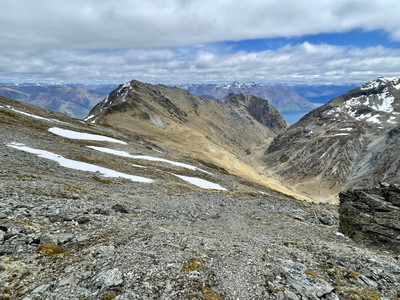

I dropped down a short snow slope and then climbed up another slope to reach a col at 2,000 meters on the west ridge of Ben Nevis. At this point I realized it was going to be a long day out. The scenary was spectacular though and the weather perfect. There was a light wind that would blow about the mountains, creating an almost eery silence. I kept moving as the sun was already very warm and I knew I would have to retrace my steps over those sun-baked snow slopes.
At the col on the west ridge, I glissaded 200 meters down so that I could bypass steep, loose terrain. Again, I sidled to the west at the 1,800 meter countour level until I reached the rocky north face. From here it was straight up. The terrain was rocky boulders that had just been covered in a few inches of snow - yay!

I continued my strong pace upwards and at nearly four hours I reached the summit. I couldn't help but let out a celebratory yell. Ben Nevis was more challenging than I expected. It was also very much worth the effort. I sat in the sun, eating a sandwhich made of venison salami, and enjoyed the views of the Hector Mountains. The silence was spectacular.


Knowing I still had the majority of the day ahead of me, I parted ways with the peak. I retraced my steps - back down the north face, sidled to the east, climbed two hundred meters up to the col, dropped back down, traversed snowy slopes, climbed up another snow slope, and did the long sidle over loose rock back to the col above Wye Creek. I dropped down to the hut, climbed up and above the hut, dropped down into the creek, sidled and climbed up out of the creek, and finally dropped another 1,200 meters all the way back to the car. Woof.
Ten hours later I was very happy to take a cold plunge in Lake Wakatipu and inhale some Indian food :) Happy days...
Comentários